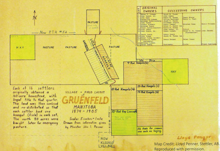
The modern town of Kleefeld, the “Land of Milk and Honey,” has a storied past and holds the distinction of being the first Mennonite village established in Western Canada. After arriving in 1874 at the Red and Rat rivers, the Mennonite settlers arrived at the Shantz immigration sheds south of Niverville. The women and children stayed in the huts until surveyors could lay out the twenty-one villages that were established in 1874. Kleine Gemeinde immigrants travelled south and east before arriving at a spot just south of what is now HWY 52. The village of Grünfeld was established at a northwest-by-southeast angle and held 16 families, making it similar in size and layout to the village of Steinbach.
Originally, the community was named Grünfeld by Kleine Gemeinde delegate Cornelius Toews after his hometown in the Borosenko colony, north of modern-day Nikopol in south Ukraine. Toews was one of the twelve delegates representing the various colonies and gemeinde in Russia who toured the American Midwest and Canadian prairie in 1873 to find a new home for their communities. Delegate Toews being in the community brought prestige, as the ältester or head minister played a pivotal role in both the religious and secular life of the village. In 1876, delegate Toews commissioned the building of a windmill for Grünfeld, but despite this, growth stagnated and the community didn’t see the same expansion and industry as Steinbach. In 1881, a significant split occurred as several families joined the nascent Holdeman movement. The name Grünfeld held until a government Post Office was added in 1896 and the name bore too much similarity to an existing town. The new name of Kleefeld, which translates as “clover field” is apt considering many honey producers would eventually operate in the area.
Unlike some of the other Kleine Gemeinde communities who set up schools in homes within the first year, the village of Grünfeld operated its school out of a sarai until 1879. Sarai were long tipi-style buildings built from thatch that rested on the ground. These could be built more easily than semlin (sod houses), but were rarely built in Manitoba due to their inability properly insulate against the cold winters. This lack of a permanent building must have led to several chilly years for the first students.
Like Blumenort and some other East Reserve villages, the dissolution of the original village plan in the early 1900s led to a complete shift in the village location. Modern-day Kleefeld is located roughly one and a half miles south of the original village of Grünfeld and is situated along a north-south grid. There is little evidence of the original village site remaining, although the original village orientation can still be seen in several properties just north of the Holeman Mennonite cemetery at the junction of HWY 216 and Rd 35N or Gruenfeld Road.