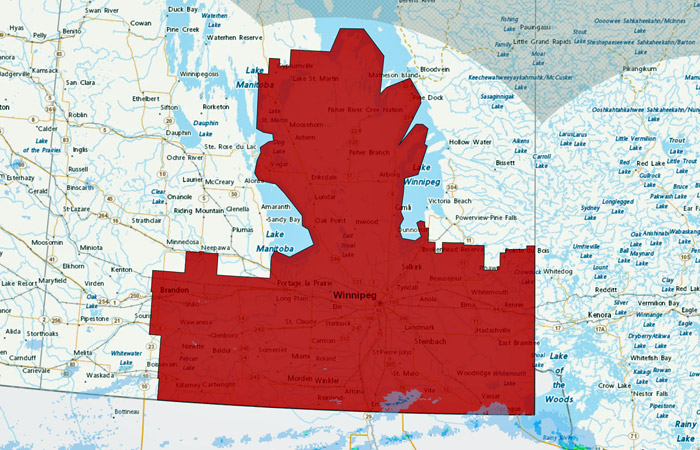
Manitoba Transportation and Infrastructure’s Hydrologic Forecast Centre is advising Manitobans to take precautions as much of southern Manitoba and the Interlake region of the province could see between 40 and 70 millimetres of precipitation Friday.
The heaviest amount of precipitation is likely to occur in parts of southern Manitoba, the Interlake region, the Whiteshell lakes area and the city of Winnipeg. Heavy precipitation in short duration could create high surface run-off and overland flooding.
The precipitation system is also expected to impact the United States’ portion of the Red and Souris river basins. Levels on rivers and streams will start to rise in response to the precipitation event. However, levels are forecast to remain within the banks for most major rivers including the Red and Assiniboine rivers.
Soil moisture is generally near normal in most parts of Manitoba except for the Interlake region where soil moisture is normal to above normal. Heavy precipitation in saturated soils could create overland flooding and could cause levels to rise above the banks in the Interlake region including the Fisher River basin.
The Hydrologic Forecast Centre indicates that up to 80 mm of precipitation occurred in the past three days in the Winnipeg River system and in the Lake of the Woods watershed in Ontario. The Winnipeg River basin in Manitoba and the rest of Whiteshell lakes area may also be affected by the rain tomorrow. Levels will slightly increase along the Winnipeg River system as a result of the rain and the increased outflow from the Lake of the Woods. The department is opening control gates along the Whiteshell lakes to balance and manage the expected level rises along the lakes.
The Hydrologic Forecast Centre also advises the forecast precipitation system comes with high northwest winds gusting up to 70 km/h. These high winds are expected to develop early Friday morning and last until the afternoon of May 25, which may raise levels by as much as five feet or more along the south basin of Lake Manitoba, as well as shorelines near Gimli on the west side and Victoria Beach on the east side of Lake Winnipeg. Property owners are advised to take precautions.
Manitoba Transportation and Infrastructure continues to monitor highway conditions and motorists are reminded to adjust driving habits for road conditions and remain alert when approaching construction zones. Manitobans with travel plans are advised to travel only when necessary or wait until road conditions are safe to do so. Visibility may be suddenly reduced at times in heavy precipitation and surfaces such as highways, roads, walkways, trails and parking lots may become slippery or experience high water.
Power outages can occur during thunderstorms and Manitobans are encouraged to prepare basic emergency kits with drinking water, food, medicine, a first-aid kit and a flashlight. More information is available at gov.mb.ca.
The Manitoba Emergency Management Organization (EMO) continues to work with all local authorities and emergency management partners to provide guidance and support to prepare and respond to this weather system. This includes reviewing existing emergency plans, information sharing and preparing resources used in flood response. Additionally, Manitoba EMO continues to work with Indigenous Services Canada and Manitoba Municipal and Northern Relations to support First Nation and Northern Affairs communities’ flood response.
Road users are encouraged to check road conditions before travelling by calling Manitoba Highways at 511 or visiting manitoba511.ca. While 511 is updated regularly by the provincial road patrol, conditions can change in a matter of minutes.


