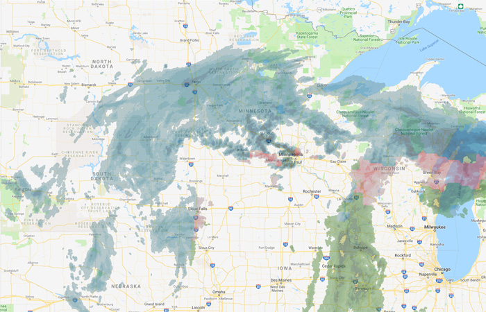
The Hydrologic Forecast Centre of Manitoba Infrastructure is monitoring a storm system in the central-northern U.S., which could bring heavy precipitation to Fargo, N.D., and water levels on the Red River in Manitoba.
Daily average temperatures within the Red River Valley are staying near 0 C, pushing the forecast date of the peaks further into the future. Depending on the precipitation amounts in the storm system in North Dakota, flood waters could reach 2011 levels or slightly higher. The peak date at Emerson is now expected between April 21 and April 24.
Provincial crews are deployed in a number of communities in the Red River Valley preparing for potential ring dike closures. Partial ring dike closures are currently underway at Emerson and St. Jean Baptiste, and the communities will remain accessible by road. Partial ring dike closures are expected at Morris, Letellier, Ste. Agathe, and St. Adolphe. Traffic may be reduced to two lanes for a segment of PTH 75, and PTH 75 is expected to be closed to traffic north of Morris in the latter part of next week. For current highway conditions and road closures, call 511 or visit www.manitoba511.ca.
The Red River Floodway is expected to begin operations early next week, but may be delayed until ice is flowing freely at the floodway control structure. Rising water levels at the floodway inlet may result in some water spilling naturally into the floodway channel prior to operation. The forecast peak flow on the Red River Floodway is estimated to be between 25,000 and 32,000 cubic feet per second, depending on the precipitation amounts in the storm system.
PR 204, from the Red River Selkirk Bridge to PR 212, is closed due to flooding.
A flood warning continues for the Red River from Emerson to the Red River Floodway channel inlet. A flood watch continues for Roseau River.
A flood warning is issued when river or lake levels are exceeding or are expected to exceed flood stage within the next 24 hours, while a flood watch is issued when river or lake levels are approaching flood stage, but likely not within the next 24 hours.
A high water advisory is issued when a heavy storm or high flows are expected and may cause water levels to rise, but not necessarily reach flood stage. A high water advisory can be an early indicator for conditions that may develop into a flood watch or flood warning.
Property owners are reminded to protect wells as high water rolls through the Manitoba portion of the Red River Valley.


